Day 2 – Puna District, Hot Ponds, Walk from Kalapana to Active Lava Flows
This is a part of our 9-day Big Island Itinerary.
Tuesday, December 26. It will be a long day, as we are checking out from the Grand Naniloa Hotel and driving south from Hilo, past Pahoa town, towards the ocean to what the locals call the Red Road. It runs for about 15 miles along the coast line from Kapoho Tide Pools to Kalapana. Our goal for today is to see Big Island hot springs and hot ponds in the first half of the day, and then hike to the lava viewing area near Kalapana after 5 pm. The Kilauea Volcano is the most active volcano in the world. It has been steadily erupting for the past 30+ years. Watching active lava flows was #1 activity on our list. From the Internet information I have read, I got an impression that the ocean entry of lava flow would produce the most spectacular performance. It actually turned out differently, read on to discover! After that, we will drive up to Volcano to overnight in the Lava Lodge.
Breakfast in Grand Naniloa Hotel Hilo
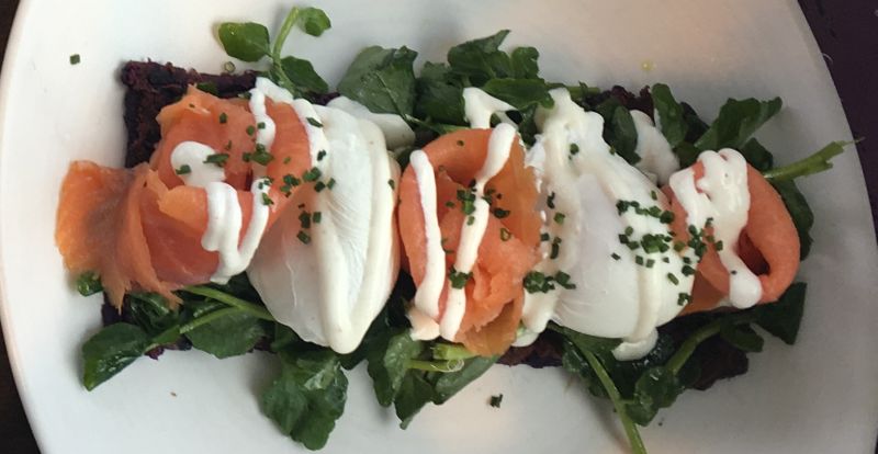
Such a long day warrants an early start and a hearty breakfast. We still had one of the Free Meal VIP cards that we received from Grand Naniloa on our check-in (because our reserved room wasn’t available), so we headed to Grand Naniloa’s restaurant and occupied a cozy table in the corner with ocean views. All three breakfast selections that we ordered were tasty and beautifully served, but I will showcase mine here, as I was truly impressed by the taste and presentation. Smoked salmon and poached eggs on the bed of local purple potatoes and local greens. The greens were amazingly fresh, crunchy and mild. Thank you, Grand Naniloa!
Drive to the Cape Kumukahi Lighthouse
Puna district is located south of Hilo and stretches from Kilauea summit east to Cape Kumukahi. According to Hawaiian legends, this land was created by the fire goddess Pele when she got angry with Chief Kumukahi who hadn’t recocognized Pele in disguise and refused to allow her to participate in sport competitions. Chief Kumukahi was chased to the sea by a river of lava that created the cape, bearing the chief’s name. Hawaiian Pele is quire wrathul and vengeant goddess, and her swift furies continue to recreate this area.
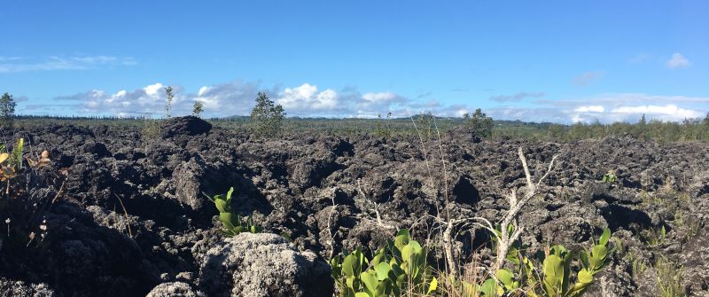
We took Hwy 137 until it met with Hwy 132. Then turned left into a dirt road, which took us to Cape Kumukahi and its lighthouse – the easternmost point of Puna district, the Big Island and all Hawaii archipelago. The Kilauea eruption of January 1960 completely consumed and destroyed the village of Kapoho, when a huge fountain of lava shot up towards the east. Fortunately, no lives were lost. That same year a few months later, the largest tsunami in Hilo killed 61 people (see the end of our Arrival Day story). The eruption was swift and fierce, and produced a’a type of lava seen everywhere in this area. This type of lava is so sharp, that no animals can walk on it, even goats, so it is very difficult to get plant seeds over. We saw many old a’a lafa fields on the Big Island that look like recent ones because nothing grows there.
We found it very exciting just to stand near the lighthouse, looking east and breathing. There is nothing but open ocean between Cape Kumukahi and North America, and looking directly east one would be looking towards Guadalajara, Mexico. According to Internet sources, Cape Kumukahi has some of the cleanest air in the Northern Hemisphere. I haven’t done a research to verify this, but it might well be true.
We realized that visiting Kapoho Tide Pools could take too much time, as they are hard to reach. So we put them onto our Big Island Wish List [coming soon] and returned back to Hwy 137.
Ahalanui Hot Pond and Beach Park
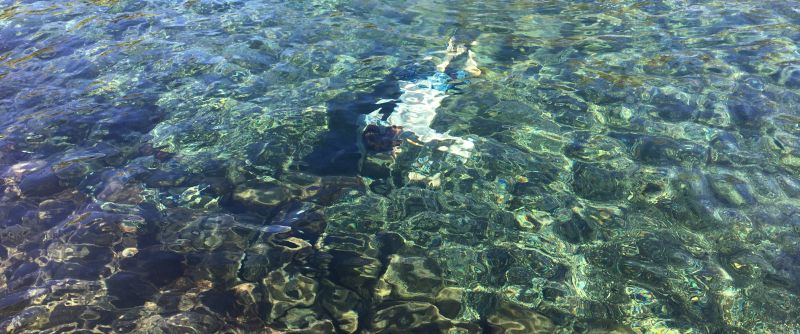
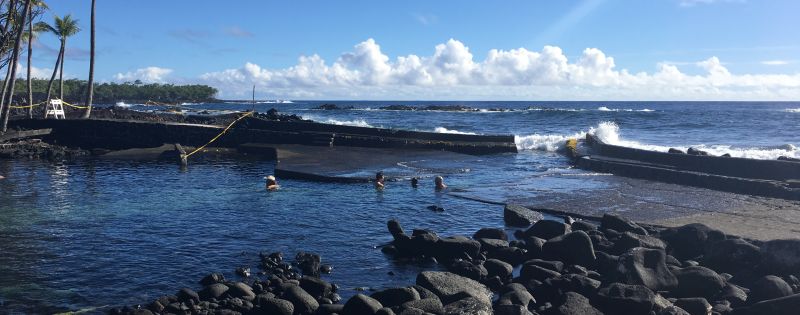
Driving south on Hwy 137, in about 3 miles we came to Ahalanui County Beach Park. The magnet here is Ahalanui Hot Pond and it didn’t disappoint! We live in California and love coming to Calistoga to enjoy its naturally heated mineral pools. We had a very similar experience here, but in a natural tropical setting. The water is said to vary in temperature day to day, being around 90 degrees Fahrenheit on average. We found Ahalanui Hot Pond quite large, crystal clear and so warm, one can comfortably swim in it for hours.
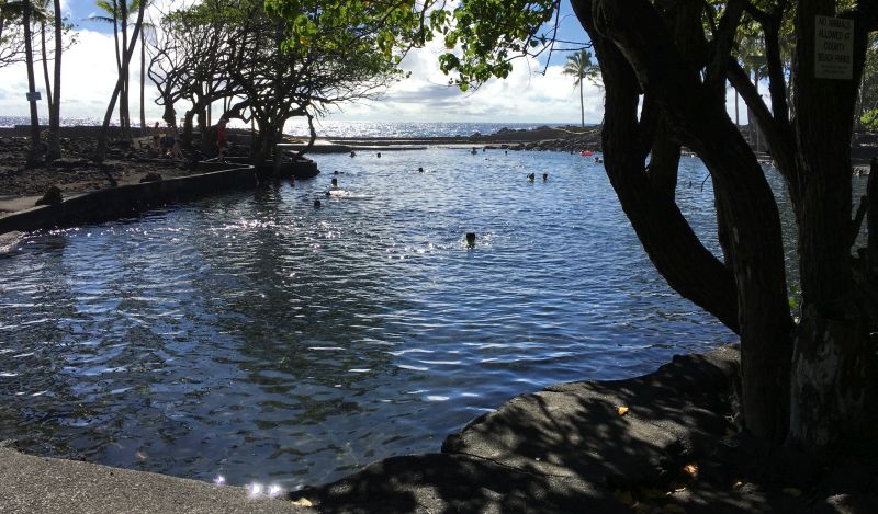
Where the pond meets the ocean, a cement structure protects the pool from waves, but the pool is connected to the ocean through a passage between the blocks. The tide goes in and out and there is a rope to protect people from the tide than could otherwise suck them out into the opening. That spot is a very pleasant place to safely experience the lull of the tide, so close to the waves but yet warm and comfortable.
Pohoiki Hot Pond
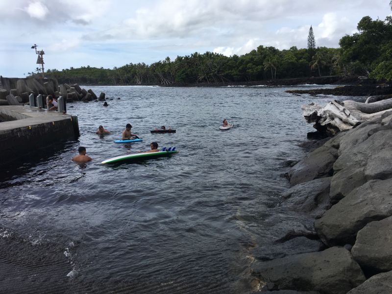
We continued driving south and just over a mile reached the Isaac Hale Beach Park. A cement pier, protecting the boat ramp here, also creates a sheltered area for swimming and snorkeling. We found the water here just slightly warmer than in the open ocean, and after the luxurious warmth of the Ahalanui Hot Pond, we decided to forgo the swimming.
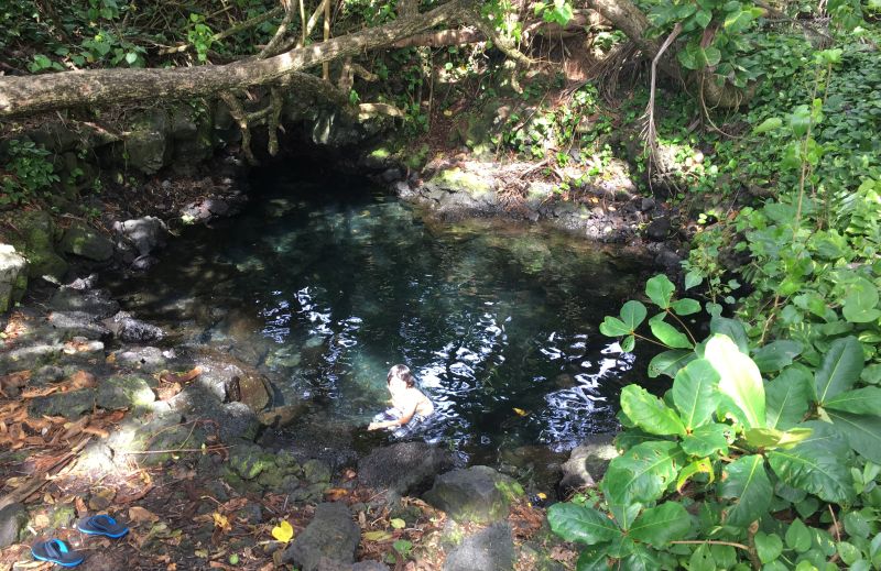
I was resolved to find the actual hot pond, about which I read that it’s located a short walk inland and south from the boat ramp. We easily located a trail, and after following it for a minute, saw Pohoiki Hot Pond. But it wasn’t hot. Warmer than the ocean, and just slightly salty. It must be a cool spot to hang out, but someone has already occupied it, and we were quite content with just the views.
Continuing to Kalapana
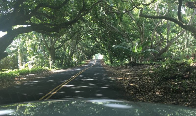
We continued driving south along the scenic Red Dirt Road. We saw residential houses mostly on the right side. The road is really beautiful, most of the way going through the tropical forest. We didn’t stop anywhere on the way to Kalapana, saving our time for the main adventure later in the day.
We came to Kalapana around 2 pm. A couple of interesting spots to visit here: Uncle Robert’s Night Market every Wednesday night – the best party on the Big Island; and Kehena Black Sand Beach – a clothing optional beach with drumming on Sundays. We needed a good lunch, but didn’t see any places to eat around here. So, we drove about 20 min back to the laid-back Pahoa Town, which is known as hippie capital of the Big Island and has quite a lot of old buildings. We had long and slow lunch in a Thai restaurant on the main street, and then had enough time for coffee and dessert in the Tin Shack Bakery. The Lilikoi Cheesecake was excellent!
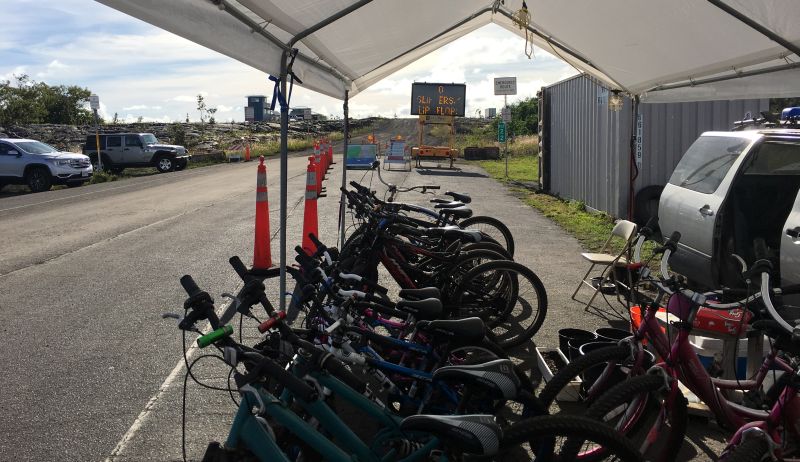
After the restful and fulfilling stop in Pahoa, it was time for our main adventure of the day – the walk to the place where lava flows into the ocean. From Pahoa, we took Hwy 130 to Kalapana, in Kalapana turned right onto Kaimu-Chain of Craters Road, and in less than 2 miles reached the end of the paved road with many bike rental companies. It was around 4 pm. The cost to rent starts from $15 per bike including the lock, a pint-sized bottle of water, a poncho in case it rains, a headlight and a flashlight you can put on the bike. We ended up renting ours at $20/person, because we are tall and they didn’t have bikes for us in the $15 range. It took us about an hour to decide on and rent bikes and to get ready. My husband received instructions on where to go (I wasn’t listening) and we started to pedal on the gravel lava road around 5 pm. The road was very well packed and easy to pedal on. It ascended in the direction we went, and it took us about 40 minutes with stops to take photos and drink water to reach the 3rd gate.
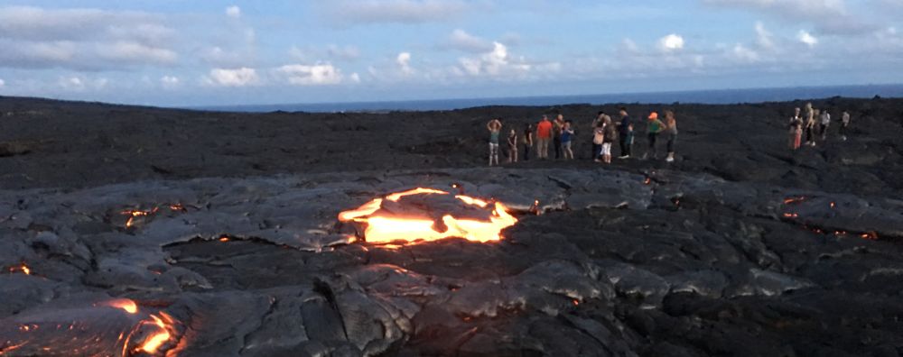
When we rented the bikes, my husband received instructions to cycle until the 3rd gate, park the bike there and walk to the right towards green patches on the mountains. I wasn’t listening to the instructions, but overheard that the actual walk on lava will be a mile long and should take about 30 minutes. There were very many people that day doing the same activity, and all of them parked their bikes and turned right towards Kilauea volcano. I was perplexed – that way we will move away from the ocean. We continued walking with everyone else, and I started to get a bit upset that I wouldn’t be seeing the lava ocean entry that I was dreaming about. But then all of a sudden we noticed far ahead a stream of lava on the slope of Kilauea, and my mood instantly improved.
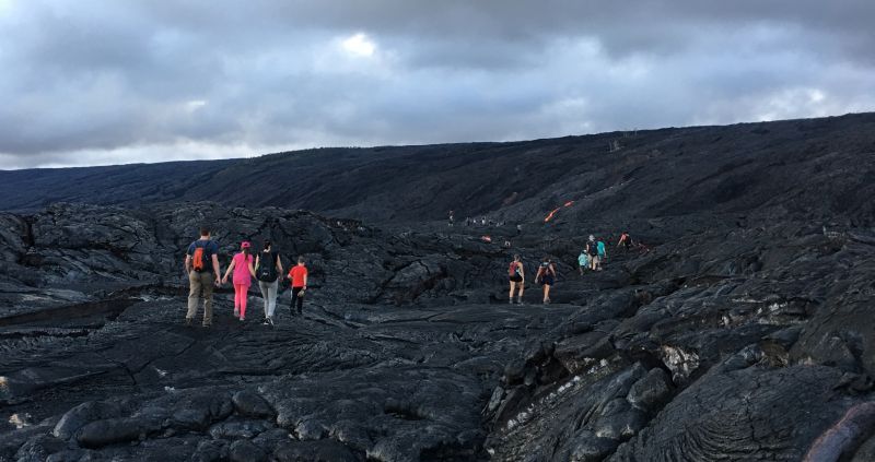
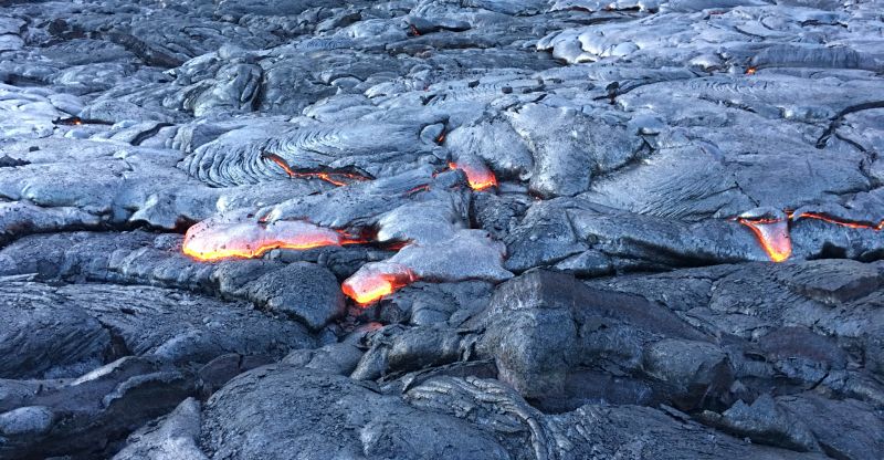
We kept walikng. 30 minutes, then 40, 50 – we were still pretty far from the lava stream on the slope, but the air started to feel a bit warmer and there were some deep cracks in the hard lava under our feet. All of a sudden, I saw the orange glow in one of the fractures – right there, just about 3 feet from the surface, was one of the entrances to Pele’s factory.
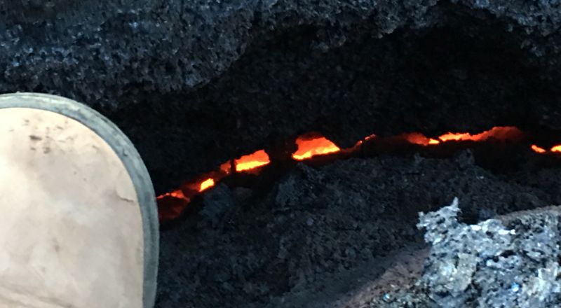
In about 10 more minutes of walking, we saw the first active lava flow. A pahoehoe lava flow is moving slowly, molten basalt pools, and its surface starts hardening right away, yet it breaks open again and new glowing orange lava fingers emerge. I was watching one of the newer glowing finger hardening and becoming silvery black. I wanted to make a selfie and got closer to the lava flow looking away from it, when the lava broke out faster and hotter – I instantly felt it with my back and had to step away. Seeing the molten matter flowing from within our Earth was truly a phenomenal spectacle! In that moment I realized how lucky we are to be able both to meet Pele in her home and to get away alive!
UPDATE (a month later):
A tour guide died while on a guided hiking tour in the Kalapana lava viewing area
Please remember that the Big Island, however beautiful and laid back it may seem, is embodied nature with all its volatility and unruly power. Stay vigilant. Check the weather, talk to locals before walking into the lava fields. If in doubt, back out.
We walked over an hour one way and it felt like at least 2 miles. But walking uphill on very uneven surface, not being totally sure of the direction and zigzagging constantly – it could well have been just one straight mile. Around 7 pm we turned to go back. It was pretty dark, but one small LED flashlight was enough to see the surface well, and walking downhill was easier. We reached the bikes in 40-45 minutes, and cycled all the way to our car in swift 20 minutes – downhill again! Soon after 8 pm we were on our way to Lava lodge in Volcano.
Tips for Lava Viewing
If you like narrated excursions, you might benefit from booking a lava hike tour. You will probably see the same sights, but in a company of a knowledgeable guide. Don’t book far in advance, because the lava viewing conditions can change rapidly.
If you don’t want to rent a bike, there is an option of a shuttle taking you to the second gate, and then you would walk until the 3rd gate. I believe, the stretch between the 2nd and the 3rd gate is not too long, it might add 1-1.5 miles walking each way, but you will not have to cycle.
Check the latest eruption-related information from Hawaii County as part of planning the hike.
Bring more water. The pint-sized bottles provided with the rental bikes are no enough. We had about one gallon of water between the 3 of us, and we finished it all before the end of the walk back.
Time needed. We arrived at the bike rentals at 4 pm, left on bikes about 5 pm, biked about 40 minutes (4 miles), walked about 1 hour 10 minutes (1 mile) to reach active lava flows, walked 40-45 minutes back, and rode bikes back 20-25 minutes. The active part took us just over 3 hours. If you have small children or less fit people in your party, allow for more time.
When you are coming back in the dark, there is no good sense of direction. If you pin your location on the map app in your mobile phone, it will help keep you on course.
Previous: Day 1 – Rainbow Falls, Akaka Falls and Onomea Bay
Next: Day 3 – Jaggar Museum, Punaluu Beach and the Painted Church
Back to 9-day Big Island Itinerary


5 thoughts on “Day 2 – Puna District, Hot Ponds, Walk from Kalapana to Active Lava Flows”